Ortofotomapa
Ortofotmapy Lublina z lat 2003-2022 w usłudze WMS oraz plikach GeoTIFF w standardzie COG (Cloud Optimized GeoTIFF).
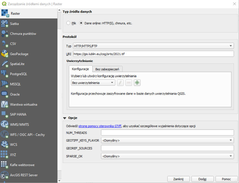
Sposób dodania GeoTIFF COG w programie QGIS.
Aby dodać plik GeoTIFF COG w programie QGIS, należy
- Otworzyć Menadżer Warstw i wybrać Raster
- Zaznaczamy opcję: Dane online
- Protokół: bez zmian
- URI: wklejany link z Otwartych Danych, np: https://gis.lublin.eu/pobierzdane/orto/2022.tif
Dane i zasoby
-
Ortofotmapy WMSWMS
Ortofotomapy w usłudze WMS. Dostępne układy współrzędnych: 2179 2180 3857 4326
-
Ortofotomapa 2025 (GeoTIFF COG)geotiff
Ortofotomapa wykonana w kwietni 2025 roku.
-
Ortofotomapa 2023 (GeoTIFF COG)geotiff
Plik należy dodać np. do programu QGIS, jako raster po protokole http/https.
-
Ortofotomapa 2022 (GeoTIFF COG)geotiff
Plik należy dodać np. do programu QGIS, jako raster po protokole http/https.
-
Ortofotomapa Ukośna 2022 Zachód (GeoTIFF COG)geotiff
-
Ortofotomapa Ukośna 2022 Wschód (GeoTIFF COG)geotiff
-
Ortofotomapa Ukośna 2022 Północ (GeoTIFF COG)geotiff
-
Ortofotomapa Ukośna 2022 Południe (GeoTIFF COG)geotiff
-
Ortofotomapa 2021 (GeoTIFF COG)GeoTIFF
Plik należy dodać np. do programu QGIS, jako raster po protokole http/https.
-
Ortofotomapa 2020 (GeoTIFF COG)GeoTIFF
Plik należy dodać np. do programu QGIS, jako raster po protokole http/https.
-
Ortofotomapa 2019 (GeoTIFF COG)GeoTIFF
Plik należy dodać np. do programu QGIS, jako raster po protokole http/https.
-
Ortofotomapa 2018 (GeoTIFF COG)GeoTIFF
Plik należy dodać np. do programu QGIS, jako raster po protokole http/https.
-
Ortofotomapa 2017 (GeoTIFF COG)geotiff
Plik należy dodać np. do programu QGIS, jako raster po protokole http/https.
-
Ortofotomapa 2015 (GeoTIFF COG)GeoTIFF
Plik należy dodać np. do programu QGIS, jako raster po protokole http/https.
-
Ortofotomapa 2015 CIR (GeoTIFF COG)GeoTIFF
Plik należy dodać np. do programu QGIS, jako raster po protokole http/https.
-
Ortofotomapa 2013 (GeoTIFF COG)GeoTIFF
Plik należy dodać np. do programu QGIS, jako raster po protokole http/https.
-
Ortofotomapa 2012 (GeoTIFF COG)GeoTIFF
Plik należy dodać np. do programu QGIS, jako raster po protokole http/https.
-
Ortofotomapa 2012 CIR (GeoTIFF COG)GeoTIFF
Plik należy dodać np. do programu QGIS, jako raster po protokole http/https.
-
Ortofotomapa 2009 (GeoTIFF COG)GeoTIFF
Plik należy dodać np. do programu QGIS, jako raster po protokole http/https.
-
Ortofotomapa 2008 (GeoTIFF COG)GeoTIFF
Plik należy dodać np. do programu QGIS, jako raster po protokole http/https.
-
Ortofotomapa 2005 (GeoTIFF COG)GeoTIFF
Plik należy dodać np. do programu QGIS, jako raster po protokole http/https.
-
Ortofotomapa 2003 (GeoTIFF COG)GeoTIFF
Plik należy dodać np. do programu QGIS, jako raster po protokole http/https.
Dodatkowe informacje
| Pole | Wartość |
|---|---|
| Ostatnio zaktualizowany | września 30, 2026, 12:56 (CEST) |
| Utworzony | września 30, 2026, 12:54 (CEST) |
| harvest_object_id | 00c839ef-3651-4bfb-9291-61e5bcd0b02d |
| harvest_source_id | 6023f148-949b-434f-b4ad-3d3c2c7f83d9 |
| harvest_source_title | dane-przestrzenne-dane-aplikacyjne |